But it does, it is the fuel for the APO. Machines. You find several scenes that a civilian (I think Iron church members) had experimented on those APO machine and unbeknownst that the fuel was radioactive and were killed.
I am going to read the rest later, because mornings GZ, afternoon AC.
I knew you’d have some solid game lore to challenge my guess, I love it! I really need to replay the campaign and start keeping a journal too!
That schedule of yours is basically exactly what I’m doing right now too!
I don’t think this was an alien abduction, only that it looked that way.
I can’t really explain it either, other then that one or two civilians (in the tent the clothing too) again were experimenting with found fuel canisters. But we don’t see any canister. This tent site was here long before the Soviet came to Östertörn.
It could be that APO machines were used for all the abductions across Östertörn.
It could also be that the dev deliberately made it look like an alien abduction as an Easter egg.
In the lore there is mention of several names of places and / or areas, that might have come into play if the two big islands in the east were actually included in the development of the game.
Even though further development is water under the bridge now, it can still be fun to speculate where those places would have been located with reasoning why.
We know that there were red container shipments transported by rail to Muskudden Naval Base, from there most likely by ship to other ports. The lore does say that they we not shipped to the mainland. From that we can conclude that the shipments went most likely to ports on the two east islands.
Maybe use name analysis which could give some extra indication. It would help if native Swedish speakers help with translating the names of the 3 ports to english.
So what does your fantasy bring you?
The destination ports
Ports are most typical placed at the coast or on rivers so take that in account
• Port: Boden
• Port: Karlshamn (suggests a larger harbor)
• Port: Fårösund (maybe somewhere on island coasts around the strait between the two upper islands. The roads, which are still on my map, give indication where locations could be.
The strait between Himfjäll and the big Island is probably also called Himfjällsundet
Kabarga Camp
The lore: Firebird reinforcements have departed from Kabarga Camp. Landfall at the town of Hagaboda is estimated to be within 6 hours.
So its location is 6 hours away from Hagaboda port. Not sure how fast firebirds move in normal cruise speed. Edit: corrected estimated speed to 100 km/h. The distance of minimal 600 km brings us outside of the Östertörn and surrounding islands, and logically to USSR soil.
F17 Air Base
Vråken jets form F17 air base were crashing on Östertörn, so they could have come from The big East island, because it has runways.
One of the island’s name:
Is probably Fårö (Sheep Island) derived from Fårösund ( Sheep island strait)
Half a mile per hour?
That’s about 804 meters in an hour.
I guess I could crawl this distance faster.
I’d say it could travel with at least 100km/h.
Attackspeed is slower, but still faster than us with a bicycle and slower than us with a motorbike, so I’d guess it’s at about 50km/h.
Oops, brainfart. Not sure what I was thinking. So Kabarga Camp would be outside our map on Soviet soil, if they travelled about 600 km. It could be near the city that now is called St. Petersburg.
I think that the name of the island would somehow depend on the geography, which I don’t know about (failed attempts getting there). I was a bit surprised that Aspholmen was named like that, as a holm in Danish is usually a small and flat islet or a group of such (plural: holmene). Bornholm is an exception and have some rocky hills, but not anything like Aspholmen.
But naming the EASTERN (not western, sorry my bad) island based on sheep makes sense. After all, Gotland is famous for its sheep, and Gotlands coat-of-arms is basically a sheep.
Edit: Karlshamn already exist (IRL) so that probably wouldn’t work.
Right, earlier I found that part of Gotland is called Fårö so I am fairly sure that one of the 2 big GZ islands is a good fit. So if you consider the name is fitting, which island would you associate with sheep island?
Deepl translates Aspholmen to Asp Island or Aspen Island. Where Asp is a type of viper.
But google translates swedish asp to aspen, a poplar tree.
Still, the lore has this name as a transport destination, and it is not on the mainland. Same names are not uncommon, think of Paris (America) and Paris (France), but there are many.
That’s correct, so I assume that Östertörn could have its own “Karlshamn” without messing up the postal service
I’m not a native to Sweden and I’m not versed enough in the lore to suggest names for the islands, but IMHO Fårö would be a good fit for the biggest, northeast island (with the airport). I reminds me of the Faroe Islands under the Kingdom of Denmark, which we call Færøerne, and which are full of sheep too.
That was my guess too. I never been there either, but the smaller Island (top one) seems barren without grasslands and filled with big flat rocky plateaus. Where the bigger one has a lot of vegetation.
This what I like, when people give some input even though this data can’t be verified. As long it all seems fitting. At first I thought the Kabarga Camp was on one of the two islands, but knowing it took firebirds 6 hours to get to Hagaboda Docks, it couldn’t be on one of these islands unless their cruise speed was really slow.
Fact: The canal / strait called Himfjällsundet is data verified in the Lore, and so is Stenmirasundet.
Next step: The container destination to a Port called Fårösund, suggest that there is a canal / strait which is called Fårösundet. And at least the port Fårösund must be somewhere along the canal call Fårösundet through name association.
Don’t get confused here…
Now if we assume that the big island north of Himfjäll is called Fårö, the canal Fårösundet could be between Himfjäll and Fårö (big island) option B, or it could be between Fårö (big island) and the smaller top island option A.
Can you come up with an argument for it being one rather than the other?
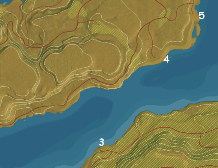
If the canal Fårösundet is on the south side of the big Island, we have two options to place the Port Fårösund, wile also considering where Karlshamn could be. If Karlshamn was on this side I would opt for number 2, because smooth brown area suggests a lot of space where a city with a harbor could fit. And in that case Port Fårösund must be on number 1 that has still a reasonable amount of space to accommodate a small Port with docks, cranes and industrial stuff.
However, If the canal Fårösundet is on the north side of the big Island, we have three options to place the Port Fårösund namely location 3, 4 or 5, although 5 could be too far near open sea that Fårösund there would not truly be associated with the canal Fårösundet. Looking at the geography 4 has enough cleared ground to accommodate a small Port like Fårösund. The location number 3 is so small that I feel Boden (meaning shed) is a wrong fit, and certainly also not Karlshamn. But number 5 could well be the port Boden
So what do you think?
Or isn’t a happy old fart not allowed to get ideas from you about unverifiable game data?
I thought that we established that the bigger island is Fårö. Or am I misunderstanding?
Btw, great that at least someone is digging in my Game world fantasies.
Well maybe I am not an old FART, but an old gentleman. Seems a bit less out of character.
Now, I had to start up GZ to avoid bringing more confusion to the discussion and be a bit sharper on the geography (which is a bit of a problem now that I don’t play GZ every day anymore).
My question is: what is the name of the body of water between the eastern coast of the forest region (with the little islet Påskallaholm) and the two islands Himfjäll island “Färö”?
Could that be part of Färösundet as well as the strait between Himfjäll and Färö?
Or would that be Himfjällsundet? I’m a bit confused here, sorry.
As we use the word “sund” in Danish in this context, it is a narrow strip of water between two landmasses. So I would suggest, that Himfjällsundet is between Himfjäll and the forest region, and Färösundet is between Färö and the forest region. I have no clue what the strait between Himfjäll and Färö should be called. Perhaps Färösundet extends this way?