So the canal between Påskallaholm and Littorp should be called Färösundet?
Don’t loose your happy, @Gysbert , I’m doing my best ![]()
So the canal between Påskallaholm and Littorp should be called Färösundet?
Don’t loose your happy, @Gysbert , I’m doing my best ![]()
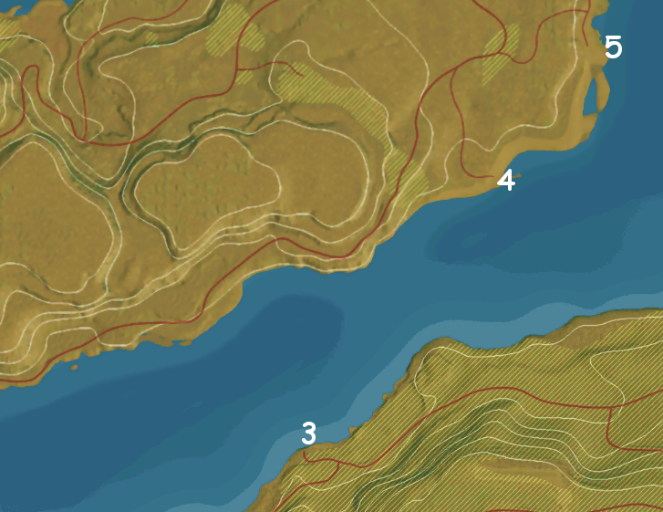
It could be be extended. Let say that Himfjällsundet flows west and north of Himfjäll. And that Färösundet flows west and North of the big Island (Fårö). See pic below
The Port Färösund must be located somewhere along the canal Färösundet, why else would it be named Färösund? And because the cliffs on west side of the big Island (Fårö) are too steep, and has no roads, I feel the port Färösund must be 4 or 5. See pic above.
If you think it gives us additional information. I hadn’t thought of that old map. Good idea.
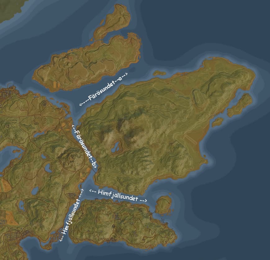
Or, as Färö is bigger than Himfjäll, Färösundet extends between Färö and Himfjäll. And the port would end up in 2, which makes more sense.
And the body of water north of Färö might classify as something different that a sound, as the top island might be too small for a sound ![]()
It could indeed extends between Färö and Himfjäll, but the port Färösund would find a better fit in 1, because Karlshamn feels like a bigger place and would fit in 2. That was my reasoning earlier.
But besides that, Östertórn is bigger than Himfjäll and yet in lore the canal is called Himfjällsundet. ![]()
Can you rephrase this, I don’t get it.
I can try. The strait of water between Färö and the small island north of Färö is wider an sits between these two relative small islands. Thus it may not qualify as a sound (strait) but instead as an inland sea or part of the surrounding sea.
![]() And I was thinking why the heck is this gentlemen talking about sounds (noise) for.
And I was thinking why the heck is this gentlemen talking about sounds (noise) for.
So to recap.
• You think that the canal Färösundet is extended from the south coast of Färö to the west coast of Färö.
• The body of water running on the north coast of Färö is too wide to be a strait and probably more like a inner sea.
• For the location of the Port Färösund, you prefer location 2 above location 1. (Where I prefer 1 above 2, because I think Karlshamn is a town with a harbor which fits the bigger area at 2.) Do you have a reasoning behind your preference?
If you look at the waters between mainland Sweden and Öland it is called Kalmar Sund. Between Gotland and mainland Sweden it is called Åland Hav (Hav is Sea).
What would your suggestion then be for that body of water, Färö Hav or something else?
If I’m a gentleman, it must be the Statler and Waldorf kind you are referring to ![]()
Yes, yes, and probably. I’m sure that I can’t do a better job of reasoning at this than you.
Yes, probably. We need a Swede here ![]()
It’s the different look at things that I look for. This quest is just like an investigation, where different ideas can help come to a solution that is acceptable, believable.
Yes, that would be nice. Maybe Fåröhavet is fitting? It also means Fårö Sea, according DeepL.
Last question of the day. Have you read this?
I have two reasons: access to the open sea and road access based on contour lines.
Site 2 would have easier access to the open sea to the east, which I would deem important for a harbour servicing the military. And the inclination of the road leading to the harbour facilities are lesser, i.e. less steep facilitating trucks with heavier loads.
This would be my considerations ![]()
Nice considerations ![]()
I think you forgot that Karlshamn is one of the three Port destinations, and should equally be considered for the two reasons you gave. The name Fårösund only tells us that it must be located along the Fårösundet strait. While Karlshamn port is a harbour indicating the need for more docking space, including non-industrial purposes, and perhaps more dwellings. That’s why I allocated the larger plot for Karlshamn.
But basically they could be switched since we have no data on how big each port is. ![]()
Don’t switch it on my account, @Gysbert . I’m not deep into the lore, and I might easily have missed something. Unless others in the forum wants to add to the discussion, I’ll will confidently leave the decision with you.
Thanks all who participated, for sharing your ideas and helping find the most believable locations for the names that were mentioned in the lore.
Basically I wanted to tickle some of the die-hard members a bit, to make them want to share their ideas, and experiencing the fun aspect of naming all geographical locations of an uncharted (not developed) piece of land. I can image the dev team sitting together and brainstorm on where to place important towns, facilities, mountains, waterways, etc. on the world map. And of course also coming up with names for them.
But I like to brainstorm with you some more. ![]()
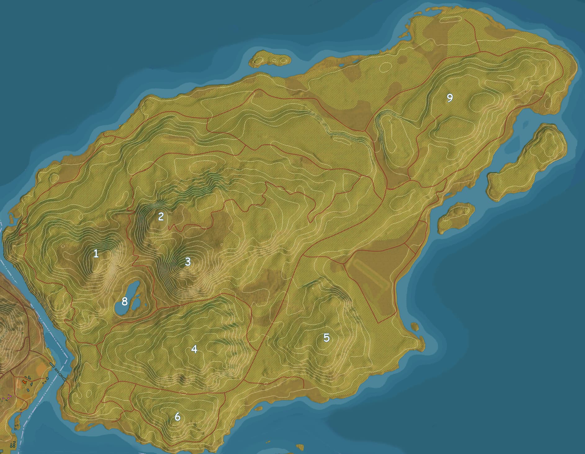
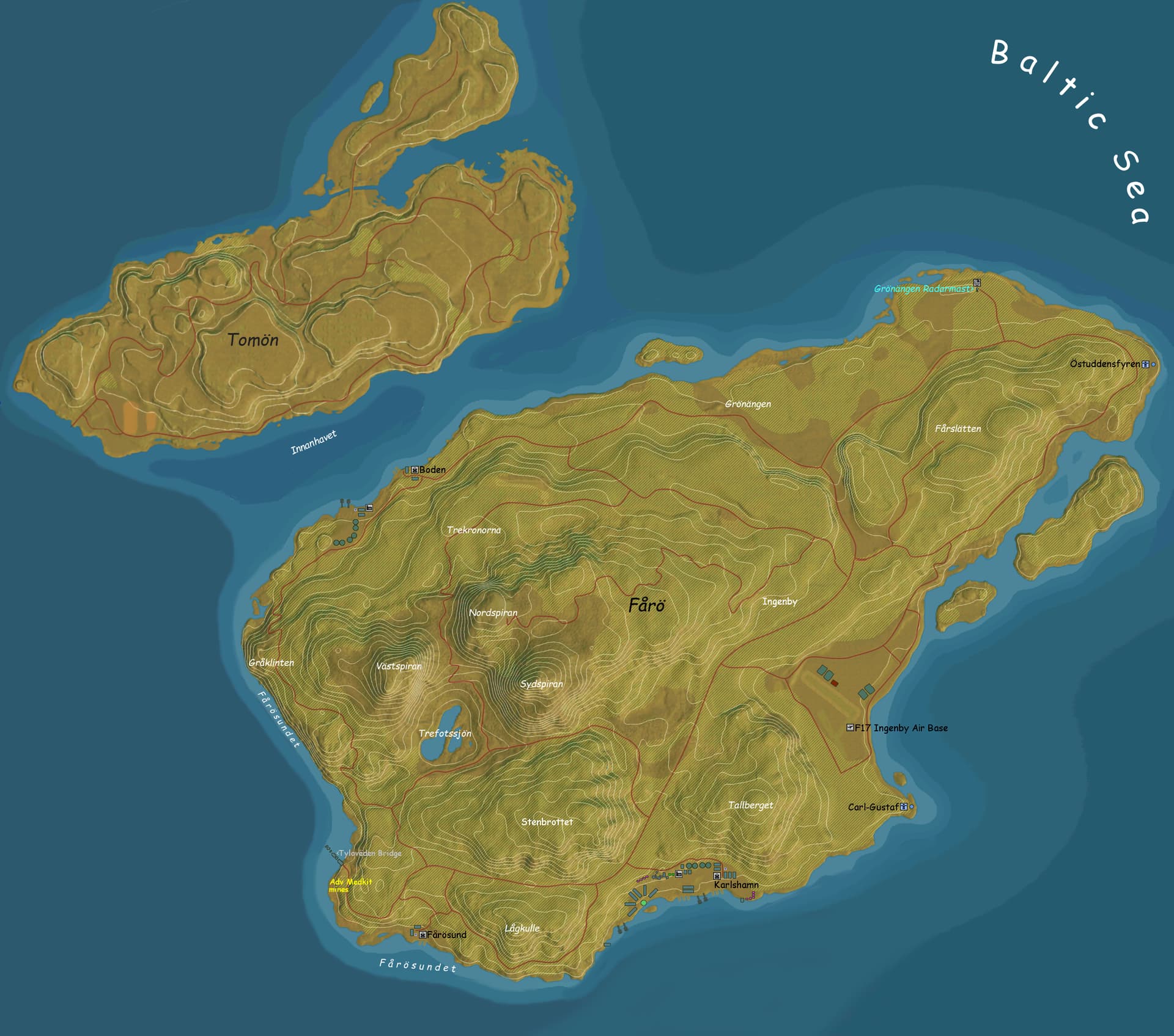
The big Island has three high mountain peaks and tree mountains that are medium height. It has some plateaus in the East. And it has an Air Base and a lake. It might have names for sub-regions.
I propose to name the airport F17 Air Base, since that fits within the existing lore.
But for all the rest it’s up to us, where we combine, geographical properties (height, snow covered, etc) location, shape, with creativity to come up with name proposals. I have seen that lakes near mountains often have the mountain name in it, or the name of a valley.
Still I love to hear your reasoning behind it as well. Please come and play. ![]()
Example: The big island has a highest peak. Which could become Number 3 “Storberget” The great Mountain.
I made a picture with numbers to help keeping track.
Well you probably guessed it, I got too excited to find names that I spend my sunday adding geographic names like mountains, subareas, and the lake to the map. I also added some buildings at the Ports and some Lighthouses and Radar Mast. It was fun. ![]()
I thought it would be a nice touch to work the Swedish Three Crown symbolism and a Swedish king into some of the names. The three highest peaks were basically the peaks of a crown.
I also named the empty Island above “Empty Island”, seemed fitting. ![]()