I’m running into people from time to time who are just now getting into GZ, so it’s very much appreciated that you’re still updating the map.
2 Likes
BIRDHOUSES!!! It feels like Christmas has come early! Many thanks @Gysbert for keeping this map up to date. I can’t wait to get home and examine it in detail! ![]()
![]()
![]()
1 Like
Remember that the bird icon only gives a proximity to the location of the birdhouses. So far there are 10.
Let me know if you find new ones.
1 Like
I’ll keep a lookout and be sure to let you know if I discover any additional birdhouses. The search continues!
1 Like
Just spotted Old Blue Eye on the map….brilliant addition! ![]()
![]()
![]()
![]()
1 Like
Just updated the map with some odd nick nacks and of course the location of the second Mkay magazine. I also colored all red cabins on the map pink. I am still working on that though because it’s easy to miss some. ![]()
If you spot one that I missed please let me know. ![]()
2 Likes
This was a false alarm. Thought I had located something to contribute, but I had spoken too soon and misremembered the correct location. As usual, your devotion to the map is incredible!
And while I’m here I’ll ask, was there ever a reason or background given concerning the removed dig hole north of Hagaboda on the semi-island where the loot cache is located?
That always bugged me.
2 Likes
No, but speculating: We did had a discussion about structures suddenly appearing overnight, which seems a bit strange. So our guess was that the devs, who then were actively reading on the forums, decided to make sites appear in stages. We still can see spots that were prepared for building, but then they never finished them.
The Big Square hole seemed to be such a stage, it went from a hole to a flat concrete surface (during the New dawn update).
2 Likes
I see. I remember the hole as you pictured it, but I can’t recall seeing the flat concrete surface. This makes me think of the various “stairs to nowhere” that used to be, and now can’t be found anymore, and also in Garphammar where the cassette tape(?) used to float in midair, and now is at the same coordinates at the same height above ground lying on a table in a house that didn’t exist before lol.
2 Likes
You can see the concrete flat surface there now.
I know of only one Stair that leads to nowhere. As far as I know it is still there.
But various? Maybe you mean others stairs? Can you elaborate?
2 Likes
Over the last few years I’ve seen videos where players go to these stairs. I only remember two or three different videos, and to be honest they may all have referenced the same stairs but there was only one video where coordinates were given so that is the only set I have ever visited. That’s probably the one you reference and I’d love to see it again. I’ve looked several times based on the hazy memory of the topography, but never found it again. Even though I’ve been in the Bear Cave many times, sometimes I have trouble finding it too, so my memory isn’t a trusted companion. “Various” was too strong a word.
3 Likes
Btw. these stairs actually lead to death. Climb to the top and you get hurt.
Just like the water in the Masskar Cave get you hurt in you fall in.
2 Likes
Yes I remember there would be an explosion when you climb to the top lol. Maybe that’s wrong I don’t know. Are the stairs on the map?
3 Likes
Yes. The stairs are in Mountain region Orange letters, East of Granhojden.
3 Likes
Thank you! So crazy, I was in the open area where the cave tunnel is not long ago and had no idea I was so close to the stairs. I haven’t been to them in probably three years lol.
3 Likes

I am now also including the so called “Glacial Erratics” to the next update of the map, see above. Basically to find out how far they have spread over Östertörn. So far I only found the typical big ones in two regions, but I am still doing my research runs to see if more regions have them. I only add the big rocks with the sharp edges as Glacial Erratics because they differ from the native Östertörn rock type. So not the bigger rounded boulders.
Source:
Wikipedia quote: “A glacial erratic is a glacially deposited rock differing from the type of rock native to the area in which it rests. Erratics, which take their name from the Latin word errare (“to wander”), are carried by glacial ice, often over distances of hundreds of kilometres.”
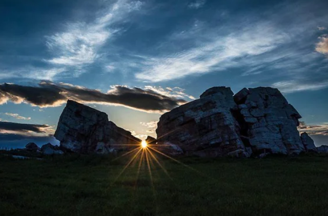
Sun set or rise at the largest erratic in the world in Canada.
4 Likes
I’ll be really looking forward to this latest geographic study of Östertörn, it sounds fascinating to see how you’re mapping these features out across the regions. Good to know the distinction between the rounder boulders and the erratics. That clears things up for me as I’m still on the lookout for that solitary one with the tree growing near it and you said to find other erratics nearby.
Also, I have to say that screenshot you shared above had me doing a double take. For a moment I honestly thought you were running GZ on Unreal 5 with the way it looked! ! And on a lighter note, I even managed to slip the term “Glacial Erratics” into conversation this morning to describe an ex girlfriend.
2 Likes
I will be uploading it soon. I still want people to have a go the “guess-where-it-is-pictures”, before revealing it all.
Edit:
I found another “stone circle” that I at least hadn’t on my map yet. The stones from this one look a little bit smaller than the ones we are used too.
Anyway, I kind of miss people posting interesting things they found, like they did when the forum was still booming. It will be on the map too next update.
1 Like
My Spidey sense is tingling that there are bots about. Caution.
1 Like
Just a quick notice that I added some made up names to the map, on the 2 undeveloped east Islands.
They are just for my enjoyment and are not real destinations. It will be on the shared map with the next update.
See here what I did.
1 Like