Wow! This is amazing 
4 Likes
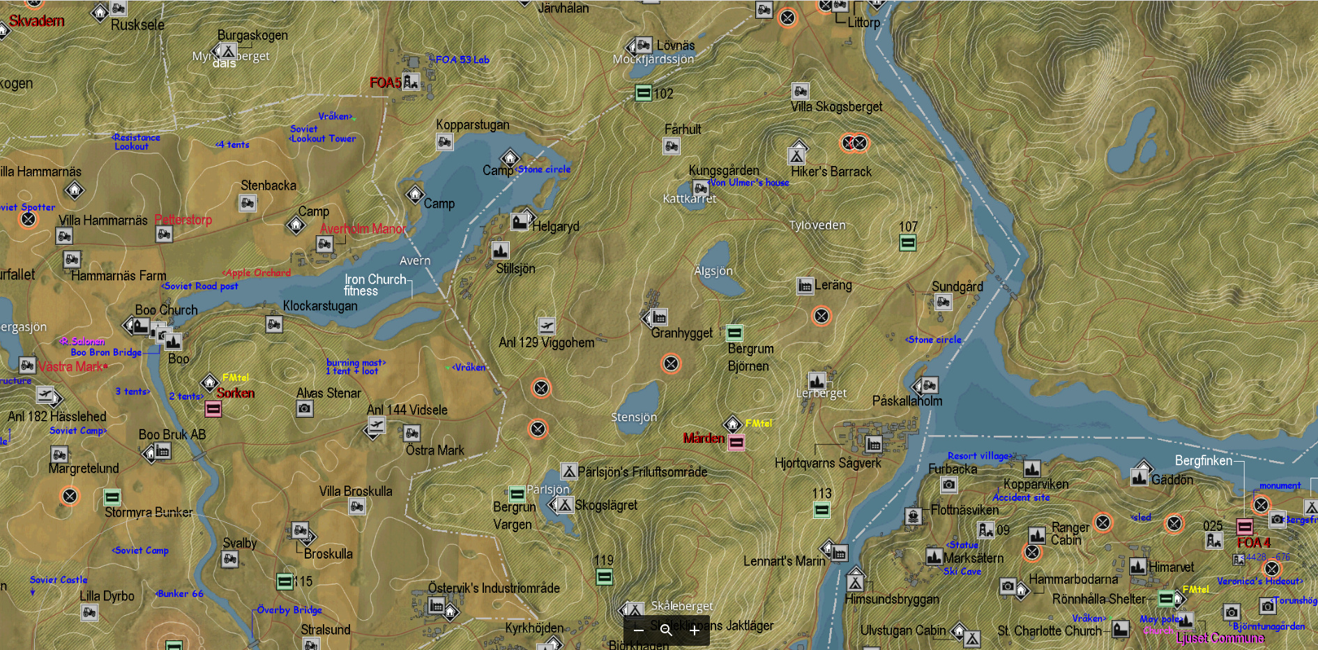
I have to mention that I skipped some of the tourist attractions, and 1 ANL in the south coast. That has a duplicate name, and I hope that it get fixed in a future update. I will add it then of coarse. 
If you find mistakes, please tell, you will not hurt my feelings, only my pride…
2 Likes
This reminds me another interactive map of GZ i saw long time ago. 
Did some digging and found another user made interactive map: It's here - Interactive map with coordinates!
3 Likes
I have changed the download file to the higher quality one.
2 Likes


I loved doing it. And will keep updating the map.
You might notice that I also made some changes to the map where certain Icons where not, or not on the right spot on the ingame map. I corrected all those I knew.
- Asöstugan outpost base moved to right spot.
- Tourist attraction Farstaborg moved to right spot.
- Changed the camping icon at Himsundsbryggan to a Ferry/port icon (Ferry crossing is here)
- Hällaberga Festival moved to right spot.
- Övertärnafyren Lighthouse icon added.
- Stormyra bunker had Industrial icon changed with bunker Icon.
- Two Angerås Churches one needs to be Sillavik Church.
- Two unnumbered Beredskapsförråd also without bunker Icon.
- Anl 144 Vidsele south coast has duplicate name. Added a 2.
- Anl 182 Hässlehed, Hermelinen bunker and Asöstugan outpost had no airport icon,
but these locations have 1 or more planes ready to take off, and have a runway. - Knarrebo Homestead has a FNIX neural node Icon, but there is no FNIX presence
there.
10 Likes
Above and beyond mate. I’ve always wanted a map I could manually input data into - is there any way to turn this it an interactive map?
2 Likes
I wanted to have it on my wall, and like you said to write stuff on it with a sharpy. Not sure how big it needs to be in printed form in order to be able to read the labelling. But if the lockdown opens up a bit more, I will see if I can get it printed. If so I will show the result here.
About the interactive map I have no idea. I’m sure it can be done by someone who has the skills. I loaded the image into
https://yangcha.github.io/iview/iview.html to see how it looked. But that page shows the maximum image size and doesn’t include a zoom function. Also not sure if the source code is available.
2 Likes
Great stuff, Gysbert!! Always find myself googling for maps of Östertörn so this is a definite save for me!
3 Likes
So any ideas on what I should or could add?
How about correcting the water line, rather than using the current, flawed map? For example, the lake at Forest and North Coast borer doesn’t end half-way, as seen on map. Instead it goes up to Dammtrop.
“Tank graveyard” (Farmlands, -1819, 1225) has actual name in game lore: Battle of Överbyslätten.
Source: The Ringfort main mission -> Armor plates mission item description.
1 Like
Ah yeah, that water. I had seen that too, but did not think it was a flaw, but rather a seasonal low or high water level… thing. But the missing water I’ll have a look at that.
Tank graveyard, I will correct that too.
Thanks.
1 Like
This is a big IF - but only because I do this myself that it may help more.
A checklist of all locations with co ordinates? As in…one to print
1 Like
A big IF indeed. For now I’m focussing on a visual Map. I share these maps, but I make them really for my own need and the pleasure it brings me of getting a complete picture, figuratively and literally. I am learnings new things like using a graphics editor, and although I am not very good at it, it serves my purpose. The map doesn’t give you the exact coordinates, but more a rough direction of where things are to be found.
I wanted to print this but the 1:1 scale of the map relates to a picture of 242 cm x 167 cm. So printing will be out of the question, if printing on A0 or even 2A0 paper is unreadable.
For 1:1 scaling, you could split the map into sectors and print individual sectors on e.g A4. And afterwards, assemble the map like a puzzle.
Just like big billboards are. They aren’t printed on a 10m x 5m paper in one go. They are printed on smaller pieces and then assembled to get one, big picture.
2 Likes
Well yes, I could puzzle the pieces together. But the total map mustn’t be too big, because where would I put it. I am also thinking of a foldable map as one possibility. But I’d rather have one hanging on the wall like a collectable. Call me crazy.
The digital map is easier for quick reference. I load the map in my graphics program, because I haven’t found a simple and free picture viewer that zooms close to the 1:1 scale. Google drive works, but zooms not nearly to 1:1 scale, Microsoft Photo’s is better that way, but doesn’t allow vertical and horizontal movement with the mouse. Go figure.
I have time. The print shops aren’t open here yet, so I have to wait anyway to see what is possible. But I also like the new island to be included. So there’d that too.
1 Like
I’m using freeware software called: IrfanView (v 4.51) and it zooms-in way past 1:1 scale. I can even see individual pixels, when needed.
Just tested in my InfranView and when holding down right mouse button, i can pan the image where-ever direction i want it.
Give it a check. 
2 Likes
Ok, that works great. I had to install the plugins too. I especially liked that with left mouse button held you select a part of the map and then click that part to zoom out on that selection. Very quick.
1 Like
I’ve been using IrfanView since my WinXP days.  Still works great, all these years later.
1 Like