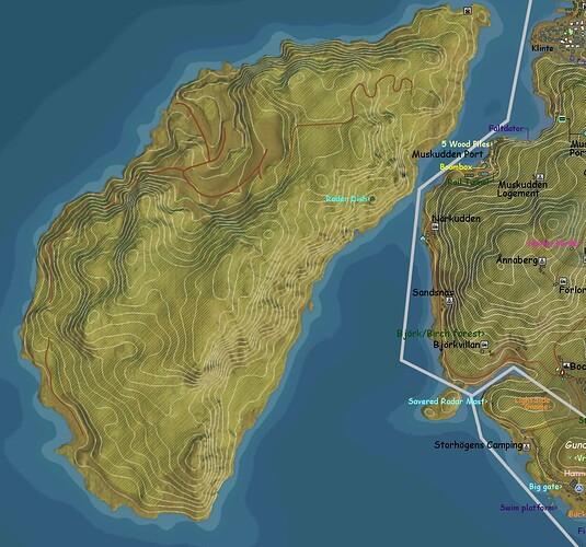
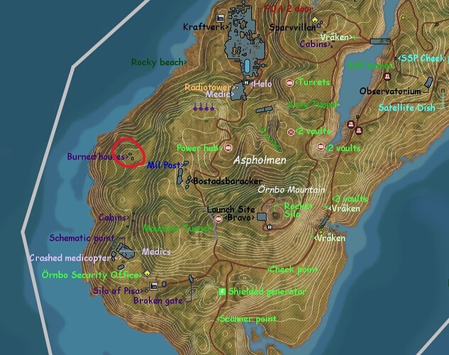
Have you tried to post the embed code for your map to Facebook or Twitter?
For some reason I can not access facebook right now but I will try as soon as possible.
I know it’s a long shot, because not a very significant POI, but does anybody have a screenshot or video with the broken dock on it that was located on Archipelago - Iboholmen coast a little bit north of Yttervik.
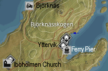
It has been removed (I assume), but I noticed this only a couple of weeks ago. I could’ve been gone for a longer time. I have been looking for a picture, but failed…
It was a concrete dock that was slanted partly underwater, it had backpacks and suitcases on it.
I can’t remember it.
Was looking for some old gameplay vids on YouTube… But seriously it’s not a place to go to in such a video.
So I thought, maybe there is someone who still has an offline-installation of the original disc version who can take a look there.
I think it was gone with the last big update. I think it was the uodate with the firebirds where introduced. With this update we could create a new world and starting the game from the scratch. And i remember the start of the game was a little other than before.
For what it’s worth I do remember it from when I played the very first time. I started a new game a few months ago and knew it was different there, but I couldn’t remember the details of what exactly was missing. I’m noticing many subtle changes over the last couple of months.
I suppose that taking away certain unnecessary environmental content could make the game run smoother, however my knowledge about game programming is not very high, so I’m not sure that is the reason for many of the removals. ![]()
Just for fun, I have been looking at the Perry Piers in the game and wondered between which Ferry Piers the Ferry’s shuttle. For instance they shuttle from:
-
Hissings Udde Ferry Pier ↔ Smabathamnen Ferry Pier (long traject)
-
Daviks Udde Ferry Pier ↔ Nyhamnen Ferry Pier
-
Hinsevik Ferry Pier ↔ Norra Saltholmen Ferry Pier
-
Yttervik Ferry Pier ↔ Österviks Ferry Pier (long traject)
-
Klinte Harbor Ferry Pier ↔ Stenmyrasundet Marina Ferry Pier (long traject)
Or do you have other shuttle route in mind?
In the old days of seafaring and map making, unexplored territory / islands were often marked with warnings like “Here be lions” or most famous “Here be dragons”. Islands with monsters, hence Monster Island.
Wikipedia: “Here be dragons" (Latin: hic sunt dracones) means dangerous or unexplored territories, in imitation of a medieval practice of putting illustrations of dragons, sea monsters and other mythological creatures on uncharted areas of maps where potential dangers were thought to exist.”
On the map of Östertörn there should be “Here be Killing Machines”.
I updated the map with some titbits and other knick-knacks, but mainly because I highlighted the barely visual roads on west Island for speculation purposes in Rumour topic. I also added the Death Triangle.
It seems there is a long road going from the south all the way up, going through the mountains via tunnels like @Gzbizz said. In the south I think I can vaguely I see a bit more road but it was too unclear to trace for now. If that is so there’s yet another part that goes through a mountain, making it 5 tunnels.
O, while I was doing the Showdown I also constantly edited the map. There are spoilers there so keep away if that is not your cup of tea, yet. I am still working on exploring. If you have something that still need added i would appreciate a message. If the map is still loading the old one, press F5 or renew in another way. ![]()
In the area marked with red circle on top of partially burnt house lies 5C Sledgehammer. You must do some simple parkour inside the burned house using fallen tree. This short “tour” will guide you to small portion of roofing with 2 piles of steel and 5C Sledge
Good find. I will add it to the map.
Thanks again for the map update Gysbert. It is an invaluable resource.
If any of you have found something in the new and/or in the old areas, that mind be nice to be mentioned on the map, please let me know. Or, if you think something should be differently named… don’t hesitate to tell that too. ![]()
Regarding Stims, is it the ones laying placed as hard objects or what you normaly find around a location you’r after?
As exampel;
2 Stims on the roof at this location in Östervik
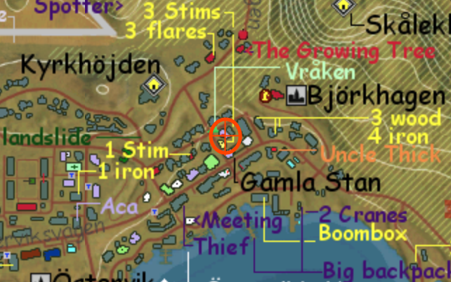
And in Björntunet Hotel and the sidebuilding (generator room) there is 99% chans to find 6 Stims in the loot.
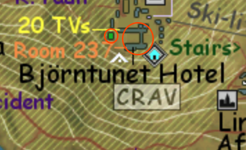
There is a high chance… Or was. There is at least one stim laying around but just can be picked up once (below the stairs iirc). In the past I sometimes got Up to 13 adrenalines in the hotel, but there were many times when I got none at all.
Never had that stim bellow the stairs? Back in the ol’days you would be happy finding 3-4 stims.
After Skyfire release I’ve almost played daily and gone to the hotel like evry 3rd day… Say about 60 times. And to 99% there is always 6 stims in the loot.
